Ha Giang is often described as Vietnam’s most dramatic landscape region. But for photographers, it is more than dramatic scenery — it is a study in scale, atmosphere, geology, and human resilience.
Located along Vietnam’s northern frontier, the Ha Giang Loop winds through karst plateaus, deep river canyons, terraced hillsides, and high-altitude villages. Elevations frequently exceed 1,000 meters, creating rapidly changing weather systems and complex light conditions.
Photographing Ha Giang successfully requires preparation, patience, and adaptability.

Understanding the Landscape: Karst Topography & Visual Depth
Ha Giang’s mountains are primarily limestone karst formations. Unlike smooth alpine ranges, karst landscapes create:
- Jagged silhouettes
- Layered ridgelines
- Vertical cliff faces
- Deep, narrow valleys
From a photographic standpoint, this terrain rewards:
- Telephoto compression (70–200mm or longer) to emphasize mountain layers
- Elevated vantage points for foreground-midground-background separation
- Use of atmospheric haze to create depth gradation
Shooting with longer focal lengths allows you to stack ridgelines into abstract compositions. In misty conditions, tonal separation becomes even more pronounced.

Best Seasons & Atmospheric Strategy
Autumn (September–November)
- Rice terraces transition to gold in lower valleys
- Buckwheat flowers bloom (October–November)
- Clearer skies after summer rains
Autumn offers the most color contrast — golden fields against grey limestone.
Winter (December–February)
- Cold mornings
- Dense fog and low cloud inversion
- Muted color palette
This is the best season for minimalist, atmospheric photography. Fog reduces visual clutter and emphasizes shape.

Spring (March–April)
- Fresh green vegetation
- Wildflowers
- Soft transitional light
Spring provides vibrant color without harsh summer contrast.
Light Patterns in Mountain Terrain
Light behaves differently in mountainous regions.
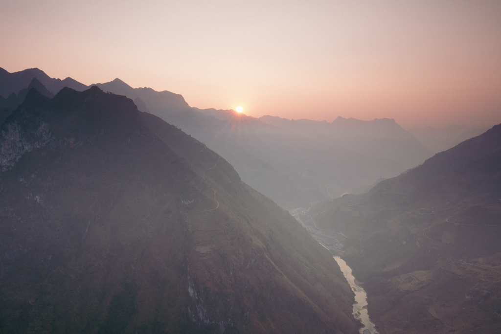
Morning Strategy
Sunrise light in Ha Giang often enters valleys at sharp angles. Because ridgelines block direct light, valleys may remain in shadow long after sunrise.
This creates:
- Rim-lit mountain edges
- Dramatic contrast between illuminated peaks and dark valleys
- Ideal conditions for exposure bracketing
Bracketing 3–5 exposures is recommended when shooting high dynamic range scenes.

Midday Strategy
Midday light can be harsh. Instead of wide landscapes, shift focus to:
- Cultural details
- Market scenes
- Architectural textures
- Black-and-white documentary
Cloud cover can soften midday conditions significantly.

Blue Hour & Night
Clear nights in Ha Giang can produce strong astrophotography conditions in remote areas. However:
- Mountain winds are unpredictable
- Temperatures drop quickly
- Light pollution varies near towns
Tripod stability is critical due to wind gusts along mountain passes.

Ma Pi Leng Pass: Managing an Iconic Location
Ma Pi Leng is arguably the most photographed road in Vietnam.
To avoid generic compositions:
- Scout alternative elevations instead of standing at the main viewpoint
- Use human elements (motorcyclists, road workers) for scale
- Experiment with vertical framing to emphasize depth
Drone photography can be effective, but wind turbulence along cliffs can destabilize smaller drones. Always check local regulations and avoid flying near residential villages.

Cultural & Portrait Photography
Ha Giang is home to ethnic groups including Hmong, Dao, Tay, and Lo Lo communities.
Weekly Markets
Markets in Dong Van and Meo Vac provide opportunities for:
- Environmental portraits
- Gesture-focused storytelling
- Color contrast through traditional textiles
Technical considerations:
- Fast prime lenses (35mm, 50mm, 85mm)
- Aperture between f/1.8–f/2.8 for subject isolation
- High ISO capability in indoor market areas
Avoid shooting from a distance with long telephoto lenses without interaction. Engagement improves authenticity.

Compositional Approach
Ha Giang rewards structured layering:
Foreground:
- Road curves
- Wild grasses
- Stone fences
Midground:
- Terraced fields
- Villages
Background:
- Karst ridgelines
Use diagonal road lines to lead viewers into depth. Avoid centering the horizon; let terrain shape dictate framing.

Physical & Logistical Preparation
- Roads are narrow and winding
- Weather shifts quickly
- Fuel stations are limited in remote areas
Build buffer days for fog delays. Flexibility often produces better results than rigid schedules.
Conclusion
Ha Giang is not simply a scenic loop — it is a complex landscape shaped by geology, altitude, and culture. Strong photography here depends less on location and more on how well one reads light, mist, and human presence within vast terrain.