This guide is for the photographer who seeks more than just a postcard of Da Lat. The Central Highlands (Tay Nguyen) is a rugged, soul-stirring expanse of basalt red earth, emerald coffee plantations, and the ancient resonance of gong culture. Unlike the northern mountains, where the drama is in the altitude, the Highlands offer a drama of light, texture, and deep cultural immersion.
This is a land where volcanoes are extinct but their spirits remain in the fertile soil, and where the morning mist serves as a canvas for the first light of day.
The Landscape of Tay Nguyen: A Geographic Overview
The Central Highlands comprises four primary provinces of photographic interest: Dak Lak, Gia Lai, Kon Tum, and Lam Dong. Physically, the region is a series of interconnected plateaus.
- Dak Lak: The heart of Vietnam’s coffee industry, centered around Buon Ma Thuot. It is defined by sprawling plantations and massive waterfalls.
- Gia Lai: Home to Pleiku and the dramatic Chu Dang Ya volcano. The landscape here is punctuated by "Sea Lake" (Bien Ho) and vast rubber forests.
- Kon Tum: The northernmost province, offering the most "raw" experience with towering communal houses and a strong presence of the Bahnar people.
- Lam Dong: Primarily known for Da Lat, but the surrounding pine forests and high-altitude tea hills of Cau Dat are the real draws for landscape work.
Primary Photography Bases
To capture the Highlands effectively, you must strategically choose your base. Unlike the flat deltas, travel times here are dictated by winding roads and basalt dust.
Buon Ma Thuot (Dak Lak)
This is your gateway to the "Black Gold" of Vietnam. Use this as a base for coffee plantation shoots, the Serepok River waterfall system (Dray Nur/Dray Sap), and the M’Nong culture at Lak Lake.
Pleiku (Gia Lai)
Pleiku offers the best access to volcanic geology. It is significantly less touristy than Da Lat and serves as the staging point for Chu Dang Ya and the Jarai villages.
Kon Tum City (Kon Tum)
Stay here to photograph the unique wooden architecture of the Kon Tum Cathedral and the Bahnar villages that line the Dak Bla River. It is the most culturally "undiluted" urban center in the region.
Da Lat (Lam Dong)
While the city itself is cluttered, the outskirts are essential for "cloud hunting" (san may). The high elevation allows for dramatic atmospheric photography that the lower plateaus lack.
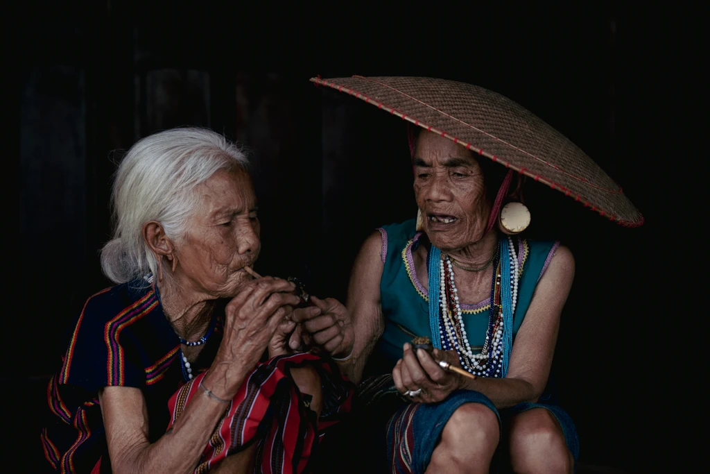
Cultural Photography: The Soul of the Highlands
The Central Highlands is home to over 40 ethnic groups, most notably the Ede, Jarai, and Bahnar. Their lives are dictated by the seasons and the spirits of the land.
The Architecture of Authority: Rong and Longhouses
- The Rong House (Nha Rong): Found primarily in Kon Tum and Gia Lai (Bahnar and Jarai groups). These towering communal houses with steeply pitched roofs are the focal point of village life. Use a wide-angle lens (16−35mm) to capture the scale against a dramatic sky, but switch to a fast prime (35mm or 50mm) to document the intricate bamboo weaving inside.
- The Ede Longhouse: Found in Dak Lak, these are built on low stilts and can be up to 100 meters long. The "breasts" carved on the entrance stairs signify the matriarchal society—a vital detail for your cultural narrative.
The Gong Culture
UNESCO-recognized Gong music is not a performance; it is a ritual. To photograph this authentically, look for village festivals (especially post-harvest in March/April). Use a high ISO and wide aperture (f/2.8 or faster) to capture the movement of the dancers around the fire without killing the ambient mood with a flash.
Local Markets
Avoid the "tourist" markets. Instead, head to the small village gatherings along the AH17 or QL14 highways at dawn. You will find Ede women with teeth stained black from betel nut and hand-woven baskets (gùi) on their backs.
Landscape Photography: Earth, Water, and Flora
Volcanic Heritage: Chu Dang Ya
Chu Dang Ya is an extinct volcano 30km north of Pleiku. The crater is now a mosaic of agriculture.
- Best Time: November, when wild sunflowers (Da Quy) turn the entire mountain gold.
- Technique: Use a drone for top-down shots of the crater’s geometric fields. On the ground, use a telephoto lens to compress the layers of the winding paths leading up the slope.
The Waterfalls of the Serepok
Dray Nur and Dray Sap are the titans of the region.
- The Shot: Dray Nur has a massive "curtain" of water. During the dry season, the water is turquoise; in the rainy season, it is a chocolate-brown torrent.
- Tip: Arrive at 6:30 AM to beat the local crowds and catch the sun rays filtering through the mist at the base of the falls.
Coffee and Pepper Farms
The Highlands produce the world’s Robusta.
- Coffee Blossom: Late February to March. The hills look like they have been hit by a snowstorm.
- Pepper: The verticality of pepper vines offers excellent leading lines. Use a shallow depth of field to isolate the peppercorns against the lush green background.
Seasonal Breakdown: Timing Your Expedition
The Dry Season (November – April)
This is the "Golden Period." The roads are navigable, and the light is crisp.
- November: Wild sunflowers and the start of the coffee harvest.
- December – February: Rubber trees in Gia Lai shed their leaves, creating a "European autumn" look in the heart of the tropics.
- March: Coffee blossom season and many village festivals.
The Rainy Season (May – October)
Expect heavy afternoon downpours.
- Pros: Waterfalls are at maximum power; the red basalt earth turns into a vibrant, saturated hue that contrasts beautifully with green crops.
- Cons: Remote village tracks become impassable "red butter" mud.
Best Light Recommendations
| Location | Ideal Timing | Atmospheric Condition |
| Lak Lake | Sunrise | Low-hanging mist over the water and M'Nong dugout canoes. |
| Cau Dat Tea Hill | 5:30 AM - 7:00 AM | The famous "Sea of Clouds" (San May). |
| Bien Ho (Pleiku) | Sunset | The pine-lined road leading to the lake catches the low golden light. |
| Dak Bla River | Blue Hour | The Bahnar fishermen casting nets against the silhouette of the Kon Tum bridge. |
Technical Photography Breakdown
Lens Recommendations
- 16−35mm f/2.8: Essential for the interiors of Rong houses and the vastness of the volcanic craters.
- 24−70mm f/2.8: Your workhorse for daily life and environmental portraits.
- 70−200mm f/2.8: Vital for "compressing" the layers of coffee hills and capturing candid portraits from a respectful distance.
Drone Usage (2026 Guidelines)
Vietnam has strict drone laws. As of 2026, drones under 250g (like the DJI Mini series) are generally exempt from flight permits for recreational use, provided you stay away from military zones and airports.
- Pro Tip: The Central Highlands has many "sensitive" areas near the borders with Laos and Cambodia. Always check the official government map portal (cambay.mod.gov.vn) before launching.
Exposure Strategy
The Highlands offer extreme contrast—dark red earth and bright tropical skies.
- Bracket your shots: Take 3-5 exposures to ensure you keep detail in the dark basalt shadows and the highlights of the white coffee blossoms.
- Circular Polarizer: A must-have to cut the glare on the waxy leaves of coffee trees and to deepen the blue of the high-altitude skies.
Ethics and Portraiture: Working in the Villages
The people of the Central Highlands are hospitable but can be shy.
- Seek Permission: Never shove a camera in a face. A simple nod and showing the camera is usually enough. If they decline, respect it.
- The "Gùi" Connection: Many locals carry heavy baskets. If you want to photograph them, don't just take the shot and leave. Buy some of their produce or share a small gift (avoid giving money to children).
- Longhouse Etiquette: Never enter a longhouse without being invited. Once inside, if you are offered Rượu cần(rice wine drunk through a straw), take a small sip as a sign of respect before you start shooting.
Suggested 7-Day Photography Itinerary
- Day 1: Da Lat Arrival. Afternoon shoot at Tuyen Lam Lake.
- Day 2: The High Plateaus. Sunrise at Cau Dat Tea Hills. Drive to Buon Ma Thuot.
- Day 3: The Serepok System. Dawn at Dray Nur waterfall. Afternoon in the Ede villages of Buon Don.
- Day 4: Lak Lake. Sunrise canoe shoot. M’Nong cultural portraits. Drive to Pleiku.
- Day 5: The Volcanoes. Dawn at Chu Dang Ya. Afternoon at Bien Ho and the pine road.
- Day 6: The Northern Highlands. Drive to Kon Tum. Afternoon shoot at the Wooden Cathedral and the suspension bridge.
- Day 7: Bahnar Culture. Morning in Kon Klor village. Fly out of Pleiku or return to Da Lat.
Transportation and Logistics
Road Travel
The QL14 (Ho Chi Minh Road) is the spine of the Highlands. It is well-paved but heavily policed. Expect average speeds of 50-60km/h.
4WD vs. Motorbike
- Motorbike: Best for flexibility. A 150cc manual bike is recommended to handle the steep inclines and occasional mud.
- 4WD: Essential if you plan to visit the remote Bahnar or Jarai villages in the rainy season. Many "roads" on the map are merely tracks.
Language
Vietnamese is the lingua franca, but in the villages, older locals may only speak their ethnic dialect. Use a local fixer/guide if you want to conduct deep-dive documentary work; it opens doors that would otherwise remain closed.
Practical Challenges and Safety
- Dust: The red basalt dust is fine and invasive. It will get into your lens mounts and sensors. Keep your gear in sealed bags when traveling.
- Permits: While most areas are open, some villages near the border require a "Border Permit" obtained at the provincial police station. Your hotel can usually assist with this.
- Weather: In the dry season, the sun is fierce. In the rainy season, lightning on the open plateaus is a genuine risk. Monitor local forecasts via the Hoi Thuy Van (Meteorological) apps.
The Central Highlands demands patience. The "perfect" shot of the mist-covered longhouse or the golden volcano doesn't come to those who rush through on a tour bus. It belongs to the photographer who waits for the light to hit the red earth just right, and who takes the time to share a drink with the people who call these mountains home.